|
|
Post by rah on Oct 3, 2015 9:34:04 GMT -5
This:

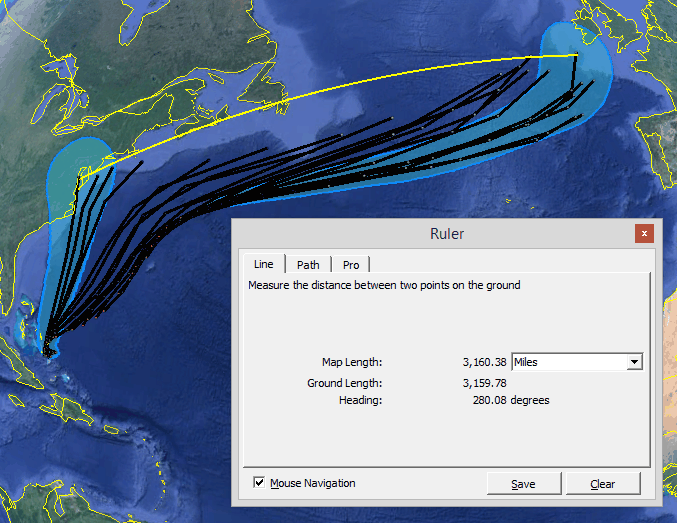
shows the projected tracks of Hurricane Joaquin that NOAA issued starting with the one to the west (far left) on Sept. 30th to the current one this Oct 3rd morning to the east (far right)that is where they say it will go now. Pretty terrible forecasting for an organization that claims it can forecast climate decades into the future.
The way they play the game is exactly what you would expect from government bureaucrats. This animation shows the evolution of the NOAAs National Hurricane Centers "forecast" tracks for Hurricane Irene back in 2011.

Notice that at one time or another they showed that hurricane coming ashore in nearly every one of the states on the eastern seaboard it possibly could. Who can go wrong when they update their forecasts multiple times a day? And then they pat themselves on the back for this kind of "forecasting".
Thanks to Tony at Climate Depot for the illustrations.
|
|
|
|
Post by rah on Oct 5, 2015 18:25:43 GMT -5
Now they have it going even further east and heading for the Bay of Biscay:

|
|
|
|
Post by rah on Oct 6, 2015 13:20:19 GMT -5
The new set of projected tracks
|
|
|
|
Post by rah on Oct 7, 2015 9:49:15 GMT -5
Notice that NOW they have it heading towards Spain! Could the National Hurricane Center have been more wrong? The fact is the European model has a much better record for forecasting Hurricane tracks than the US model that NOAA uses. So for two days the European model has been showing it going into to Spain but the National Hurricane Center just changed their track to agree with the European Model. We spend more on forecasting than any country in the world and still our government agencies create and use inferior models.
|
|
